


GPS Tracker All Informations

Description of GPS Tracker All Informations
GPS Tracker is an application designed for users who need to determine their geographical location and gather relevant information related to specific waypoints (WPs). This app is available for the Android platform and allows users to easily download it for navigation and tracking purposes. Its primary function is to provide GPS coordinates and various geographical data, making it useful for outdoor activities, travel, and location-based inquiries.
The app incorporates a variety of tools that enable users to access and manage WPs through a color-coded system. The four-waypoint colors—Green, Blue, Red, and Yellow—help users quickly identify and select different points of interest on the map. This color coding facilitates the execution of simple treatments, such as quick searches, and the creation of geometric shapes like triangles, quadrilaterals, and circles.
Users can locate GPS positions such as their current location, places of interest, or specific destinations. Information provided by the app includes the time remaining before arrival, distance to the selected waypoint, current speed, and altitude difference. These features ensure that users are well-informed about their journey.
An important aspect of the GPS Tracker is its sound tracker function. As users approach a chosen waypoint, the app emits beeping sounds, with the frequency of the beeps decreasing as the user gets closer. This auditory feedback enhances the navigation experience, allowing users to focus on their surroundings while still being guided towards their destination.
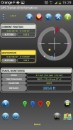
The app features a compass that displays the position of the selected waypoint, assisting users in orienting themselves in relation to their target location. The distance to the selected waypoint is clearly indicated, with color cues to signify whether the user is getting closer or moving further away. A blue indication means the user is moving away, while a red indication shows they are approaching the waypoint.
Multiple methods for recording waypoints are available within the app. Users can input data by touching the map directly, manually entering coordinates, or utilizing periodic automatic recording. This flexibility allows for a tailored experience based on user preferences and needs. Additionally, buttons on the interface make it easy to manage these operations efficiently.
The interface is designed to be intuitive, making navigation through the app straightforward. The color code used for the waypoints simplifies the process of identifying and selecting locations, enhancing the overall usability of the app. This user-friendly design is particularly beneficial for those who may not be familiar with complex GPS systems.
In terms of geographical analysis, the GPS Tracker offers a range of treatments that provide detailed information such as distances, areas, lengths, perimeters, angles, and notable points. The results of these analyses are displayed both on the map and on the screen, allowing users to visualize their data effectively.
The app also allows for the creation of circles of equidistances, isochronous circles, and various geometric shapes. Users can measure distances between their current position and a waypoint, as well as between two waypoints. Cumulative distances and shortest or longest paths can also be calculated, providing users with versatile planning and navigation options.
Specialized modules within the app extend its functionality. For example, users can analyze distances from the horizon or determine mutual visibility between two objects. The app also provides information regarding GPS satellites, ensuring users have the necessary data for optimal navigation.
Geometric calculations are another key feature of the GPS Tracker. Users can find midpoints of segments, determine intersections of straight lines, and calculate distances from waypoints. Transformations such as rotation and translation can also be performed, allowing for advanced geometrical operations on the map.
Operations on sets of waypoints are enabled, allowing users to view route information, sort data, and conduct statistical analyses. This level of functionality makes the app suitable for various applications, from casual navigation to more complex geographical studies.
The GPS Tracker app serves a broad audience with its range of tools and features that cater to both recreational and professional needs. By simplifying the process of locating waypoints and providing essential geographical information, it enhances the user's ability to navigate and explore their surroundings.
With its comprehensive suite of features, GPS Tracker stands out as a practical tool for anyone seeking to improve their navigation capabilities and access detailed geographical data. Users can easily download the app to their Android devices to begin utilizing its extensive functionalities.
GPS Tracker All Informations - Version 2.5
(11-07-2017)
GPS Tracker All Informations - APK Information
APK Version: 2.5Package: com.gps.trackerLatest Version of GPS Tracker All Informations
Other versions


Apps in the same category
You may also like...
 3.784.074.073.33
 4.064.39


